 The North End of Glen Clova |
The Cairngorms National Park became Scotland's second National Park when it was established in 2003. It is known in Gaelic as Pàirc Nàiseanta a'Mhoinhaid Ruaidh. When launched it was the largest National Park in the UK, and in 2010 its area was further expanded to include parts of northern Perth & Kinross. It now covers an area of 4,528 km² (1,748 square miles), which makes it over twice the size of the Loch Lomond and the Trossachs National Park, the first to be established in Scotland, and also the Lake District National Park in England. Our Cairngorms area covers the National Park.
The Cairngorms was designated as a national park because of its unique range of environments, being home to the largest area of arctic mountain landscape in the UK; to 25% of Britain's threatened birds, animals and plants; and to some 17,000 people.
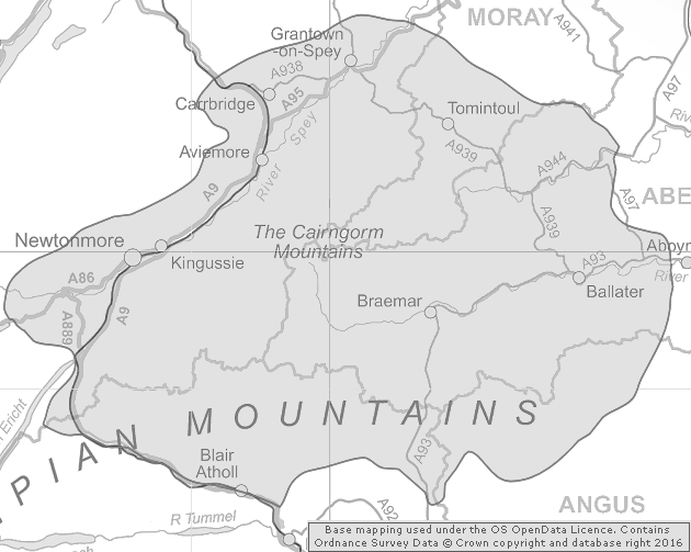 Area Covered by the Cairngorms National Park |
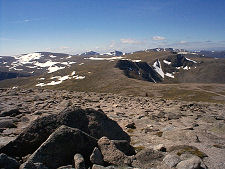
The Park includes extensive areas of mountains and plateaux, including five of Scotland's six highest mountains among 55 summit of over 900m. 36% of the Park area is over 800m in altitude, and 2% is over 1000m in altitude. It also includes large expanses of moorland and forest, as well as numerous rivers, lochs and glens. Sites designated as of importance to natural heritage form 39% of the total land area, and two thirds of these are important in a European context.
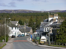
Significant settlements within the National Park area include Newtonmore, Kingussie, Carrbridge, Aviemore, Grantown-on-Spey, Tomintoul, Ballater Braemar and Blair Atholl. 80% of the local economy depends on tourism, including winter sports, walking, climbing, fishing and stalking. It was estimated that over 1.4 million people visited the Park in 2007.
Scotland's National Parks were established by the Scottish Parliament under the terms of the National Parks (Scotland) Act 2000. In many eyes this put right the fact that although National Parks were being designated in England and Wales from 1949, none existed in Scotland. This seemed a remarkable lapse given that it was a Scot, John Muir, who first came up with the idea of National Parks after emigrating to the USA in 1849.
Neither of Scotland's National Parks (nor any elsewhere in the UK) can be thought of as genuinely pristine wilderness of the sort John Muir helped preserve at Yosemite. Virtually the entire landscape of Scotland has been influenced or managed by humans over a period of thousands of years. Deforestation, farming, cattle, sheep, deer, sporting estates, power generation and transmission, afforestation, leisure pursuits and the needs of residents to live and work in the areas have all left their mark on the National Parks.
And neither does the idea of a National Park in the UK imply government ownership of the land within the park. Instead, the pre-existing land-owning pattern has been retained, leaving land in the hands of a patchwork quilt of large estates, smaller farmers, government agencies like the Forestry Commission and Ministry of Defence, local authorities, businesses, homeowners and charities like the National Trust for Scotland.
So if Scotland's National Parks are not owned by the government and do not include any pristine wilderness, just what are they for and what do they do? Their aims were set out in the 2000 Act, and are:
- To conserve and enhance the natural and cultural heritage of the area.
- To promote sustainable use of the natural resources of the area.
- To promote understanding and enjoyment (including enjoyment in the form of recreation) of the special qualities of the area by the public.
- To promote sustainable economic and social development of the area's communities.
The responsibility for balancing these sometimes conflicting aims in a collective and co-ordinated way lies with the 19 members of the Board of the National Park Authority. 7 of these are appointed by the Scottish Government, and 7 are appointed by the five Local Authorities (2 by Highland Council, 2 by Aberdeenshire, 1 by Moray, 1 by Angus and 1 by Perth & Kinross.). The remaining 5 members are elected by those living within the Park.
Day to day management is carried out by entering into management agreements with landowners, making bylaws, and employing rangers. Perhaps most importantly, the National Park takes planning decisions in relation to proposed developments within its area. It also looks after signposting and information for visitors.