 The Geology of Scotland Note About Image Copyright |
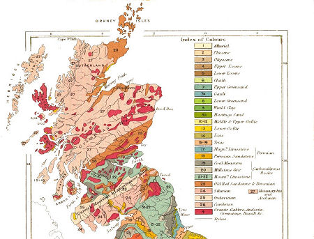
For such a small country, Scotland has a remarkably varied and complex geology. This shows up well on the 1860 geological map shown above. The map also gives a sense of the way Scotland's geology tends to align roughly south-west to north-east and, if you look closely, the way it divides the country into three distinct areas. Moving from north to south these areas are the Highlands and Islands, the Central Lowlands, and the the Southern Uplands.
The original bedrock underlying Scotland is ancient, comprising material from the Archean or Archeozoic period some 2500mya (million years ago). Fast forward two billion years, and a series of igneous intrusions forced their way through to the surface over much of the country during the Caledonian orogeny, the name given to Scotland's main mountain building event from 440-415mya.
Over this disrupted base was laid commercially important coal, oil and iron bearing deposits during the Carboniferous period from 360-300mya. The final main ingredient in the mix were a series of large volcanos which were active in Scotland during the Tertiary period from 65mya to 2mya.
This basic underlying mix was subject throughout geological history to the processes of erosion and deposition, and tectonic activity meant that the land now comprising Scotland was at different times in different parts of the world, sometimes as land, sometimes under the sea. This led to a wide range of different climates and, as a result, to a wide range of flora and fauna, whose traces can still be found in parts of the country in the form of fossils.
More recently - relatively speaking - the landscape was shaped and reshaped during a series of ice ages, with glaciers carving U-shaped valleys and leaving deep deposits of boulder clays. The ice from the last major ice age retreated a little less than 10,000 years ago, and since then the only event of geological note was a 20m tsunami caused by an underwater landslip off Norway that struck Scotland in about 8150BC.
Scotland's complex geology and its tendency to produce eminent scientists and thinkers combined to ensure that many of the important developments in the understanding of geology were first made by Scots such as James Hutton, Hugh Miller and Sir Archibald Geikie.
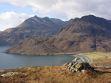
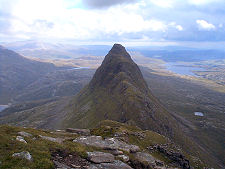
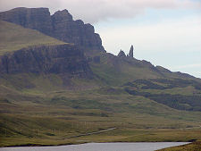
The Highlands and Islands is the largest of Scotland's three geological divisions, making up over half its total area. This is the area that lies to the north and west of the Highland Boundary Fault, a line running from Arran in the south-west to Stonehaven in the north-east. The geology here largely comprises ancient rocks which were later raised and distorted, with many later areas of intrusion, the remains of which form mountain ranges such as the Cairngorms and the Cuillins on Skye.
This area is generally mountainous, and it is divided by the line of the Great Glen, a rift valley running from Fort William to Inverness. The land to the north-west of the Great Glen is usually referred to as the North-West Highlands, with that to its east forming the Grampians. The east coast is characterised by a fertile fringe, while the west coast is deeply indented by sea-lochs. Scotland is also home to some 790 islands, mostly in the north and west. These can be divided into into four main groups: Shetland, Orkney, and Inner and Outer Hebrides.
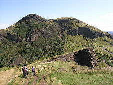
The Central Lowlands is the name given to a rift valley, also sometimes called the Midland Valley, that lies between the Highland Boundary Fault to the north and the parallel fault forming the edge of the Southern Uplands. This area is characterised by sediments that include coal and iron bearing rocks that led to the industrial revolution. The area also carries signs of a period of intense vulcanism. Arthur’s Seat in Edinburgh is perhaps the best known of a number of volcanic relics. Compared to the rest of Scotland - as the name "Central Lowlands" suggests - the area is generally lower lying, though a number of ranges of hills are present such as the Pentlands, Ochils and Campsie Fells.
The Southern Uplands is an upland area that runs roughly parallel to the English border. The northern boundary with the Central Lowlands is a fault line running from the coast of South Ayrshire south of Girvan, towards Dunbar. The area is characterised by ranges of hills separated by broad valleys.