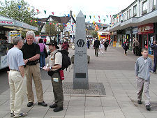
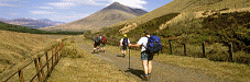
 The West Highland Way Arriving in Tyndrum |
The 96 mile or 154km West Highland Way is used by some 120,000 people each year, of whom some 36,000 complete the entire route. This makes it the most popular long distance walk in Scotland, as well as the oldest, being established in 1980. If you want to be one of them, then this page will help you find the more detailed information you need, both elsewhere on Undiscovered Scotland and beyond.
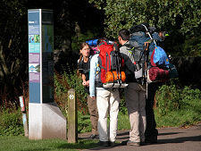
The side column on this page gives links to useful resources. The route description below is broken into seven daily sections, each of which contains links to further information on Undiscovered Scotland. The Area Pages provide links to accommodation providers and other businesses, including companies that will carry your baggage for you while you are walking the Way. The Feature Pages each contain detailed background information and a collection of images about particular places or attractions on the West Highland Way or near it.
The West Highland Way is usually walked from south to north, and this page assumes a journey in that direction. Note that it does not set out to provide you with the full range of detailed information you need to walk the Way, but it should give you a good starting point. And when used with the rest of Undiscovered Scotland it will give you a clear idea of what the West Highland Way and the places you will be passing through are like.
Section 1: Milngavie to Drymen, 12 Miles
Milngavie is well served by rail from Glasgow. If you are not a Scot, there is one trap to avoid: Milngavie is pronounced "Mull-guy".
Signs from the railway station lead you the short distance to the obelisk that marks the official start of the West Highland Way, and en route you may want to drop into the West Highland Way Tourist Office and Information Point, 50 yards from the start of the way. See the link above right.
From Milngavie the route heads generally north across country to Glengoyne Distillery, and from there beneath the escarpment of the Campsie Fells along an old railway track to Gartness. The end of the "normal" first day is in or around Drymen. Accommodation and other businesses in the area can be found listed on the Stirling & Central Scotland area pages.
Section 2: Drymen to Rowardennan, 14 Miles
From Drymen the path loops around to the 358m high Conic Hill, from which you can see Loch Lomond, and which marks the official start of the Highlands. There is a waymarked bypass for this section in the lambing season. You reach Loch Lomond at Balmaha. This section of the Way follows the Loch to Rowardennan. This is the end of the public road up the east side of Loch Lomond, and the foot of the path up Ben Lomond, Scotland's most southerly Munro.
Accommodation in the Rowardennan area can be found via listed on the Stirling & Central Scotland area pages.
Section 3: Rowardennan to Inverarnan, 14 Miles
Day three sees you walking north along the east side of Loch Lomond. Once past the Inversnaid Hotel the path goes through its most difficult section as the loch narrows and in the hilly ground beyond. North of the end of Loch Lomond the Way crosses a col before descending to Inverarnan. Accommodation can be found listed on the Stirling & Central Scotland area pages.
Section 4: Inverarnan to Tyndrum, 13 Miles
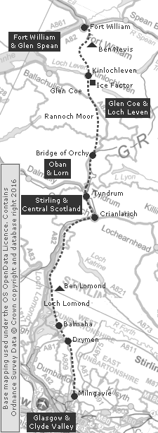
From Inverarnan the West Highland Way follows Glen Falloch to Crianlarich, where the railway lines to Oban and Fort William divide. At Crianlarich the path takes a slight left turn into Strath Fillan and progresses to Tyndrum. Accommodation can be found listed on the Stirling & Central Scotland area pages.
Section 5: Tyndrum to the Kings House Hotel, 19 Miles
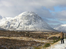
North of Tyndrum the Way follows the old military road to Bridge of Orchy. It then crosses the wild expanse of Rannoch Moor on the old drove road to Glen Coe. This section ends at the Kings House Hotel, where Glen Coe and Glen Etive meet, and overlooked by the imposing pyramid of rock formed by the north face of Buachaille Etive Mor. Accommodation in the area can be found via our Glen Coe & Loch Leven area pages. This is one of those occasions when you might wish to consider extending your accommodation options by taking public transport or hitch-hiking to a convenient centre, before returning to pick up the route in the morning.
Section 6: Kings House Hotel to Kinlochleven, 9 Miles
From the Kings House Hotel the path goes a little way down Glen Coe before zig-zagging north over the Devil's Staircase. After passing the cairn marking the highest point on the West Highland Way, at 548m, you descend into Kinlochleven. This is a village that was created to smelt aluminium, then fell on hard times. It has since reinvented itself as a leisure destination, and as a service centre for the West Highland Way.
Accommodation in Kinlochleven can be found via our Glen Coe & Loch Leven area pages.
Section 7: Kinlochleven to Fort William, 15 Miles
From Kinlochleven you follow the path north through the range of mountains known as the Mamores. This brings you into Glen Nevis, where all views are dominated by the bulk of Ben Nevis on the glen's north side.
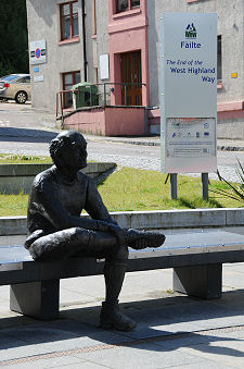
The official end of the West Highland Way used to be on the northern edge of Fort William. It is now in Gordon Square at the south-west end of the town's main street, giving access to its railway station, accommodation, pubs and restaurants. The end is marked by the statue of a seated walker, resting after his exertions. Or, of course, you could simply press straight on to the start of the Great Glen Way in the nearby Old Fort, giving a combined 169 mile walk from near Glasgow to Inverness. Accommodation in Fort William can be found via our Fort William & Glen Spean area pages.
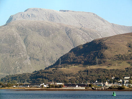 Journey's End: Fort William, with Ben Nevis in the Background |

|
|
|
 |
Visitor InformationThe Official Website of the West Highland Way provides a range of further information for walkers:www.westhighlandway.org Maps: The Ordnance Survey 1:50,000 maps of the areas crossed by the West Highland Way are Landranger maps 64; 56; 50; and 41. |
 Features and
Areas on the Walk Features and
Areas on the WalkWith Text Alternative Below |