From 1975 to 1996 local government in Scotland had a two-tier structure. There were twelve regions, most divided into between three and nineteen districts, though three (island) regions were not divided. Some council functions were delivered by the regional councils, while others were delivered by the district councils. For the first time the Western Isles were brought under a single locally-based administration.
Many of the names of the district councils which operated between 1975 and 1996 are still used to describe particular areas. Links to pages with information about each region and each district can be found below the map.
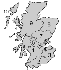 Regions from 1974 to 1996 Regions from 1974 to 1996Note About Image Copyright |
- 1. Strathclyde was divided into the following districts: Argyll, Bearsden & Milngavie, Clydebank, Clydesdale, Cumbernauld & Kilsyth, Cumnock & Doon Valley, Cunninghame, Dumbarton, East Kilbride, Eastwood, City of Glasgow, Hamilton, Inverclyde, Kilmarnock & Loudoun, Kyle & Carrick, Monklands, Motherwell, Renfrew and Strathkelvin.
- 2. Dumfries & Galloway was divided into the following districts: Annandale & Eskdale, Nithsdale, Stewartry and Wigtown.
- 3. Scottish Borders was divided into the following districts: Berwickshire, Ettrick & Lauderdale, Roxburgh and Tweeddale.
- 4. Lothian was divided into the following districts: East Lothian, City of Edinburgh, Midlothian and West Lothian.
- 5. Central was divided into the following districts: Clackmannan, Falkirk and Stirling.
- 6. Fife was divided into the following districts: Dunfermline, Kirkcaldy and North-East Fife.
- 7. Tayside was divided into the following districts: Angus, City of Dundee and Perth & Kinross.
- 8. Grampian was divided into the following districts: City of Aberdeen, Banff & Buchan, Gordon, Kincardine & Deeside and Moray.
- 9. Highland was divided into the following districts: Badenoch & Strathspey, Caithness, Inverness, Lochaber, Nairn, Ross & Cromarty, Skye & Lochalsh and Sutherland.
- 10. Western Isles was not divided into districts.
- Orkney Islands was not divided into districts.
- Shetland Islands was not divided into districts.

