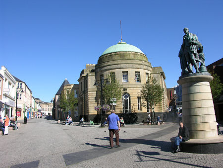
 Kilmarnock, East Ayrshire |
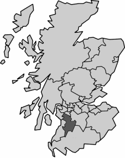
East Ayrshire is one of the 32 unitary council areas into which Scotland has been divided since 1996. It covers a large area that extends from Kilmarnock, Stewarton, Newmilns and Darvel in the north to Loch Doon and the edge of the Galloway Forest Park in the south. Other important settlements in East Ayrshire include Cumnock and New Cumnock. For accommodation in East Ayrshire and a full list of features, see our Ayrshire area pages.
 East Ayrshire Since 1996 Note About Image Copyright |
East Ayrshire is the 14th largest Scottish council area in terms of physical size and the 16th largest in terms of population. The area around Kilmarnock is relatively built up, but the east and south of the council area are extremely rural and, in places, remote. East Ayrshire is crossed roughly from north to south by the A76 from Kilmarnock to Dumfries. Many parts of the area, especially around Cumnock and along the upper valleys of the River Ayr and River Irvine, still reflect an industrial and mining heritage that in places carries on as open-cast mining.
East Ayrshire is bordered on its north by North Ayrshire, Renfrewshire and East Renfrewshire; on its east by South Lanarkshire; on its south by Dumfries & Galloway; and on its west by South Ayrshire.
From the point of view of local authority coverage, the 1996 reorganisation that discarded Scotland's 12 regions in favour of 32 unitary council areas saw East Ayrshire formed by merging the areas of the Cumnock & Doon Valley and Kilmarnock & Loudoun districts of Strathclyde Region. If you take a longer view and compare East Ayrshire to the traditional counties of Scotland before they were replaced by regions in 1975, as you might expect from the name, it occupies the eastern part of the traditional county of Ayrshire.

