Undiscovered Scotland

  • Home
  • Councils/Counties
    • Main Page
    • Council Areas Since 1996
    • Two Tier from 1975 to 1996
    • Counties from 1890 to 1975
    • Counties before 1890
    • Council Area Statistics
  • Discover
    • Site Index
    • A-Z Indexes
    • Categories
    • Find Accommodation
    • Tours & Holidays ▼
      • Tour Operators
      • Walking Holidays and Guiding
      • Wildlife Tours & Holidays
      • Golf Tours and Holidays
      • Motorhome Hire
      • Cruising & Charter
      • Arts, Crafts & Photo Holidays
  • Site Resources
    • Late Availability
    • What's On?
    • What's New?
    • Links Collections
    • Hotel Reviews
    • Scotfax
    • Biography
    • eBooks
    • Book Reviews
    • Bookshop
  • Site Info
    • Contact
    • Site Information
    • How to Feature
    • Website Design Services
    • Twitter: Follow Us
    • Cookies & Privacy
    • Copyright, T & C

Dunbartonshire

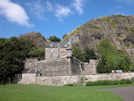
Dumbarton Castle, in Dunbartonshire until 1975
 

Dunbartonshire was one of the 34 traditional counties into which Scotland was divided for administrative purposes. Dumbarton was the county town, and originally the name of the county was Dumbartonshire. For centuries "Dunbartonshire" and "Dumbartonshire" were used virtually interchangeably, but "Dunbartonshire" had become accepted as the definitive spelling by the early 1900s. This seems to have been a reflection of the "correct" root of the name of Dumbarton, which at some time in the past was wrongly anglicised from the Gaelic Dùn Breatainn or "Fort of the Britons".

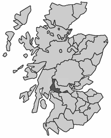
Dunbartonshire, 1890 to 1975
Note About Image Copyright
 

The traditional area of Dunbartonshire covered the north bank of the River Clyde including Dumbarton, Helensburgh and the west side of Loch Lomond. For historical reasons it also had an exclave to the east, around Kirkintilloch and Cumbernauld. The main body of Dunbartonshire was bordered by Argyll, Perthshire, Stirlingshire, Lanarkshire and Renfrewshire. Its exclave was squeezed between Stirlingshire and Lanarkshire.

A tidying up of the map of counties in 1890 reduced their number to 33 and removed most of the exclaves that existed in a number of parts of the country. This, oddly, had no effect on Dunbartonshire, which as a result remained a county in its own right, complete with its exclave, until reorganisation in 1975 swept all the counties away in favour of 12 regions.

The regions formed in 1975 were the upper tier of a two tier local authority system, and the areas which had formed Dunbartonshire became part of the region of Strathclyde. Most regions were divided into a number of district council areas, and Strathclyde was divided into no fewer than 19 of them. These were grouped into six sub-regions, mostly based on the traditional counties which had become part of Strathclyde. Dunbartonshire therefore became the Dunbarton sub-region of Strathclyde, and was divided into five district council areas: Bearsden & Milngavie, Clydebank, Cumbernauld & Kilsyth, Dumbarton and Strathkelvin.

Regions and districts disappeared from the scene in a major reorganisation in 1996, being replaced by 32 unitary council areas. What had started out as the traditional county of Dunbartonshire is today divided between Argyll and Bute, which took the areas around Helensburgh and to the west of Loch Lomond; West Dunbartonshire; and East Dunbartonshire. Meanwhile, the area around Cumbernauld ended up in the unitary council area of North Lanarkshire.

   
Clickable Index Map
Buy me a coffee

Dunbartonshire Before 1890
Note About Image Copyright
   

Copyright Undiscovered Scotland © 2000-2025

  • Main Page
  • Council Areas Since 1996
  • Two Tier from 1975 to 1996
  • Counties from 1890 to 1975
  • Counties before 1890
  • Council Area Statistics
  • Site Index
  • A-Z Indexes
  • Categories
  • Find Accommodation
  • Tours & Holidays ▼
    • Tour Operators
    • Walking Holidays and Guiding
    • Wildlife Tours & Holidays
    • Golf Tours and Holidays
    • Motorhome Hire
    • Cruising & Charter
    • Arts, Crafts & Photo Holidays
  • Late Availability
  • What's On?
  • What's New?
  • Links Collections
  • Hotel Reviews
  • Scotfax
  • Biography
  • eBooks
  • Book Reviews
  • Bookshop
  • Contact
  • Site Information
  • How to Feature
  • Website Design Services
  • Twitter: Follow Us
  • Cookies & Privacy
  • Copyright, T & C
HomeCouncils/CountiesMain PageCouncil Areas Since 1996Two Tier from 1975 to 1996Counties from 1890 to 1975Counties before 1890Council Area StatisticsDiscoverSite IndexA-Z IndexesCategoriesFind AccommodationTours & Holidays ▼Tour OperatorsWalking Holidays and GuidingWildlife Tours & HolidaysGolf Tours and HolidaysMotorhome HireCruising & CharterArts, Crafts & Photo HolidaysSite ResourcesLate AvailabilityWhat's On?What's New?Links CollectionsHotel ReviewsScotfaxBiographyeBooksBook ReviewsBookshopSite InfoContactSite InformationHow to FeatureWebsite Design ServicesTwitter: Follow UsCookies & PrivacyCopyright, T & C