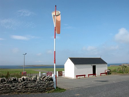
 Stronsay Airfield |
A number of Orkney's northern islands can boast odd shapes and irregular coastlines. But being variously describes as akin to the three-legged symbol for the Isle of Man or the missing piece from some Norse God's giant jigsaw puzzle, Stronsay can certainly lay claim to the the most unexpected geography. Even its name, from the Old Norse Star Island, comes directly from its multi-pointed shape.
You reach Stronsay via Orkney Ferries service from Kirkwall. On several days of the week there is more than one service during the day, allowing visitors time to explore the island between ferries.
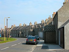
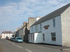
You approach Stronsay from the west, travelling through Spurness Sound between Sanday to the north and Stronsay itself, before turning sharply south between Stronsay and Papa Stronsay to enter Papa Sound. Here your attention is attracted by the harbour and substantial buildings of Stronsay's main village, Whitehall.
You may also notice the more recent development on the tiny island of Papa Stronsay, which defines and protects Papa Sound. This was purchased in 1999 by monks of the Transalpine Redemptorists who have since created a monastery here, far from their earlier home in France, but on a site which already had an established Christian presence before the first arrival of the Vikings in 700s.
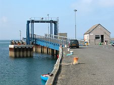
Papa Stronsay's new residents seem to coexist cordially with their near-neighbours across the water in Whitehall. They transport themselves between the two using a small motorboat and, more recently, the small car ferry Eilean Bhearnaraigh last seen on the Sound of Barra service from Barra to Eriskay until replaced by a larger CalMac vessel in 2003.
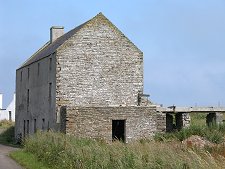
Whitehall may remain a substantial village, but you only need visit the largely ruinous Lower Whitehall, just to its east, to see that it is much less substantial than once it was. Much of this was down to the decline in the herring fisheries, the story of which used to be told in the excellent Fish Mart Heritage Centre, which has since been given over to hostel accommodation.
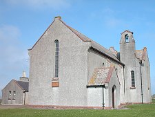
You can think of Stronsay as three bulbous peninsulas which meet at Wardhill, the tiny village marking the geographical centre of the island and lying on the low ridge that runs down much of the length of it. Wardhill is home to Stronsay's school, and also to its only church, the Moncur Memorial Church.
The northern portion of Stronsay is home, as well as to Whitehall, to the island's tiny airfield, overlooking the offshore Holm of Hulp. Near Wardhill this northern peninsula is squeezed by Mill Bay from the east and St Catherine's Bay from the west.
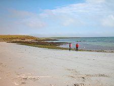
Stronsay is home to a number of lovely beaches, including the one facing out into Mill Bay. The rock seat in its centre is called the Mermaid's Chair, and some say that a girl sitting on it can foretell the future. Its history is more grisly. This was where, so it was believed, Scota Bess, one of Orkney's storm witches, would sit and cast her storm spells.
Stronsay's large fishing population understandably tired of this, and beat her to death. Several attempts to bury Scota Bess were each followed by the finding of her disinterred body the following morning. Finally the islanders threw her body into Meikle Water. Whether this was sensible or likely given Meikle Water's status as the most significant source of fresh water on the island seems debatable...
The south-west peninsula of Stronsay lies to the west of the Bay of Holland (a name that reflects the Dutch interest in Stronsay in the 1500s and 1600s). It is the least populous part of the island and today its most striking residents are three beautiful wind turbines.
The south-east chunk of Stronsay is the biggest in area. Highlights include the remarkable rock formation found down its eastern coast, which include the spectacular Vat of Kirbister. This combined gloup and rock arch is part of a 6.5 mile nature walk taking in much of this Stronsay's best coastal scenery. At Lamb Ness you find the remains of the Danes' Pier, said to be a Norse harbour now used mostly by the local seal population.

|
|
|
Visitor InformationView Location on Map |
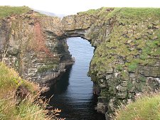 Vat of Kirbuster |
 Disused Mill |
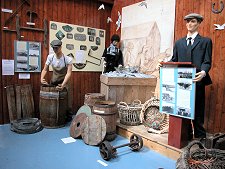 Stronsay Fish Mart Exhibition |
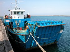 The Eilean Bhearnaraigh at Whitehall |