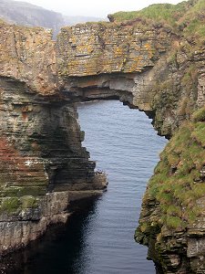
 Vat of Kirbister from the Landward Side |
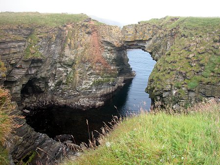
The Vat of Kirbister is the most spectacular rock arch in Orkney. The roof of a very large, almost circular, cave has collapsed, leaving an inlet accessible via the original mouth of the cave and under the remaining arch.
The westernmost coast of Stronsay, stretching from Odness in the north via Burch Head to Lamb Head in the south contains some of Stronsay's most spectacular coastal scenery.
The best starting point for any exploration is the extended layby on the minor road at Kirbister, at grid reference HY681241 (note this is shown as "Kirbuster" on some Ordnance Survey maps). From here a path runs between fields to the shore close to the attractive inlet called Bluthers Geo.
A nearby sea stack called the Malme has on its summit the remains of an early Christian hermitage. This is a recurrent feature of sea stacks in the area: it seems Stronsay's early Christians were prepared to go to great lengths to ensure a little privacy.
Following the coast path a short distance south brings you to the highlight of the walk, the Vat of Kirbister itself. Different viewpoints allow you to gain a growing understanding of the fascinating structure you are looking at, a rock arch connected to the cliffs behind at both ends.
You can get quite close to the arch itself: but the partial fence at the north end is less of a disincentive to even closer examination than the slightly precarious state of some of the rocks and covering vegetation.
South of the Vat of Kirbister is another sea stack, known as Tam's Castle because it, too, carries the remains of a hermitage on top. A little further on you come to a stone-faced rampart across a rocky promontory, all that remains of a fort dating back to the early iron age. A sign near the parking area shows how this short walk can be extended to a 6.5 mile circular walk.

|
|
|
Visitor InformationView Location on MapGrid Ref: HY 687 238 What3Words Location: ///strutted.spotted.strapping |
 The Arch End-On from the South |
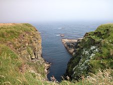 Bluthers Geo |