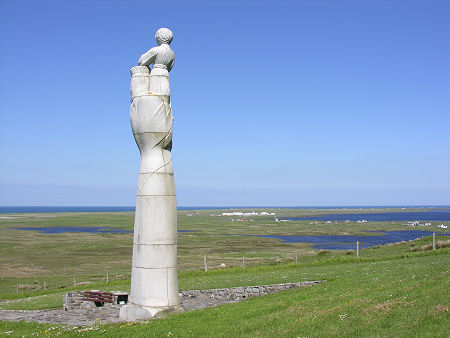
 Statue of Our Lady of the Isles, with Geirinis Beyond |
Geirinis, or West Gerinish, is a linear settlement extending for about a mile east along a minor road from its junction with the A865 in northern South Uist. In its middle you find St Bride's RC Church. This end of the island comprises more water than land, and though it's not obvious from ground level, Geirinis lies close to the south shore of Loch Bee: and not far north of two smaller lochs.
The best place to get a feel for the landscape is from the site of the Statue of Our Lady of the Isles. This 30ft high depiction in granite of the Madonna and Child was erected on the western slope of Rueval at a height of 170ft above sea level in 1957. It was the work of the sculptor Hew Lorimer.
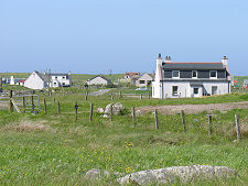
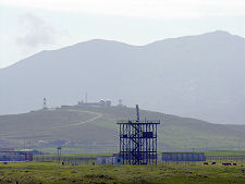
From the flank of Rueval, Geirinis appears to stretch along a narrow spit of land, a strip of green between the blue of the neighbouring lochs. Some other features of the landscape are also pretty clear from here. The first is that above you, on the summit of the 270ft hill, is a collection of large golf ball structures, aerials and other buildings. The second is that to the west of Geirinis is what looks like an even larger settlement, grouped tightly amid the machair landscape.
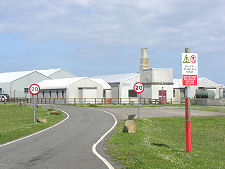
Both the hilltop installation and the coastal buildings form part of the Hebrides Missile Range, set up here at the end of the 1950s. It is now operated by QinetiQ, a privatised arm of the Ministry of Defence, and tests a range of military missile systems. As well as the "Range Head" to the west of Geirinis and the radar station on the top of Rueval, the military base at Balivanich on Benbecula serves as the headquarters of the missile range, and there is an associated monitoring station on St Kilda.
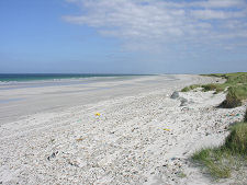
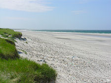
When the range is operational, access to much of the west side of northern South Uist. is restricted, and the peace of the island is intermittently broken by a sound like a low level jet fighter flying away from a standing start at high speed, followed by the bangs that occur when, presumably, the missile goes supersonic or hits its target, or both. Notices are posted by QinetiQ in a number of surrounding settlements saying when the range is operational. This is important information because when the missile range isn't operational, it provides a gateway to the most magnificent beach in the Western Isles: and one of the few on South Uist you can reach without a heavy duty 4x4.
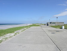
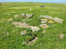
To reach the beach you turn right at the far end of Geirinis, past a military water tower. A sign here (hopefully) confirms that the range isn't operational: if it doesn't, turn back. Continue along the shore of Loch Bee and past the heavily fenced collection of buildings you can see from Rueval. From here a network of concrete roads lead out towards three Launch Areas, numbered 1, 2 and 3 from north to south. Following signs to Launch Area 3 takes you to a loop of road, part of which is built on top of the dunes right next to the beach. And what a beach it is: white shell sand that runs unbroken for over three miles north from here, and over four miles to the south. And a couple of hundred yards inland is a fenced off area (with a stile to allow access) surrounding the remains of a Pictish wheel-house.
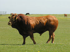
Those visiting the range should leave immediately if red flags are hoisted or red lights shown, and visitors are strongly advised not to touch anything metallic they may come across: it could go bang. We'd add the advice that you don't stray too far from your car, especially in the grassy areas behind the dunes. When we were there the residents included a number of extremely fine bulls we'd not like to try to outrun...
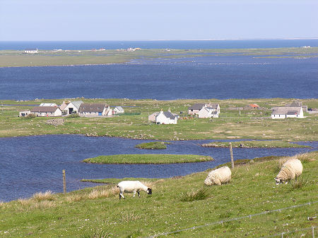 Geirinis Seen from the South |

|
|
|
Visitor InformationView Location on MapWhat3Words Location: ///hoops.curve.dime |
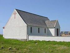 St Bride's Church |
 Missile Range Buildings |
 Missile Range Resident |
 Missile Range Radars |