Stirling Street |
The town of Denny stands pretty much at the focal point of central Scotland. Stirling is 7 miles to the north; Falkirk is 5 miles to the east; and Cumbernauld is 6 miles to the south-west. And yet, despite its central location, Denny has a surprisingly isolated feel: it is the sort of place people seldom visit unless they need to.
The cause is obvious from a glance at a map. There was a time when Denny was a much more frequently visited place, as it stood astride the main road from Glasgow to Stirling, the A80. This met the main road from Falkirk at Denny Cross, in the heart of the town. Today it is a very different picture. Denny stands close to the southern end of a triangular island created by three motorways, the M9 to the north, the M876 to the east, and the M80 immediately to the west.
The relevant stretch of the M9 opened to traffic in 1968 and the M80 followed six years later in 1974. It was another six years before the triangle was completed by the opening of the M876 in 1980. Since then, virtually all through traffic traversing the area has used one or other of the motorways. (Continues below image...)
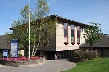
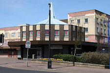
 The 1960s Shopping Centre Seen in 2011 Before Demolition: It was Replaced by the Library Shown in the Header Image |
Denny appears to have originally come into being as a settlement at the southern side of a crossing over the River Carron, on the main overland route from Glasgow to Stirling. As such it forms a pair with Dunipace, on the northern side of the river. There is evidence of early settlement in the area in the shape of Tappoch Broch, an unusual lowland broch found on a hilltop some two miles north-east of Denny. The strategic importance of the area in the medieval period accounts for a number of castles built on or close to the banks of the River Carron, including Herbertshire Castle, which stood near Dunipace, and Torwood Castle, located not far from Tappoch Broch. Near both is Torwood Blue Pool, a mysterious shaft that serves as a reminder of the area's coal mining history.
According to one story William Wallace's uncle was a clergyman in the area, and the young William was a frequent visitor. According to another the body of Robert the Bruce spent the night in what is now Denny en route to his burial in Dunfermline Abbey in June 1329. Another exotic link comes with the suggestion that in the 1300s the Barony of Denny was one of a number of baronies held across Scotland by the Knights Hospitaller of the Order of St John of Jerusalem and administered from their Scottish headquarters at Torphichen Preceptory. It has also been suggested that property in the area was owned by the better known Knights Templar. The latter were suppressed across Europe in the early 1300s and in Scotland their property (and, often, their knights) simply transferred to the Knights Hospitaller: so it could be that the Barony of Denny was owned in succession by both.
By the 1700s Denny was known for its wool and calico industries, though these gave way to paper mills during the 1800s. In 1858 Denny found itself linked to Scotland's rapidly growing railway network by means of a three mile long branch line from a junction on the Caledonian Railway south of Larbert. Several coal mines opened around the town following the arrival of the railway and a foundry opened for business in 1870. A gasworks using the locally extracted coal soon followed.
The early years of the 1900s found Denny to be a busy and thriving (and probably very dirty) place. Another iron foundry opened in 1920, and a coal-fired electric power station was built. As with so many towns and cities whose livelihoods revolved around heavy industry and mining, the story of Denny in the latter half of the 1900s is one of decline. The railway ceased operations in 1965 and the last pit, Herbertshire Colliery, closed in 1959 after a productive life of 70 years during which it had, at any one time, employed between 300 and 400 men.
Some efforts were made to improve matters, not always successfully. In the 1960s a large part of the centre of Denny, along the west side of Stirling Street north from Denny Cross, was cleared and a large new shopping centre was built, with shops at ground floor level and flats above, with a large car park at the rear. Some of the images on this page show the shopping centre in April 2011, a few months before demolition started. In its place was built a much smaller scale library and shops, also shown on this page.
 Gable End Art on Stirling Street |

|
|
|
Visitor InformationView Location on MapWhat3Words Location: ///prune.boomers.grows |
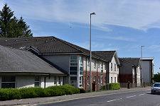
 Glasgow Road |
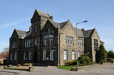
 Carronbank House Council Offices |
 Denny High School |
 Baptist Church |
 Broompark Community Centre |
 Gable End Art |
 Stirling Street in 2011 |
 Part of Shopping Centre in 2011 |
 Another View of Stirling Street, 2011 |
 Rear of the Shopping Centre in 2011 |