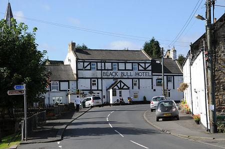
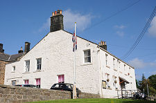
 The Black Bull Hotel at the End of Bellingham's High Street |
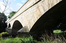
The small market town of Bellingham stands on the north bank of the River North Tyne where it flows down from Kielder Water, nine miles to the west, towards its confluence with the River South Tyne near Hexham to become one of England's great rivers. If you approach Bellingham from the south along the B6320 you cross the river at Bellingham Bridge, a rather fine stone bridge built in 1834 just to the south of the town, possibly to replace a medieval crossing of the river. The toll house built to charge users of the bridge still stands at its southern end.
Bellingham is the bustling capital of North Tynedale, an otherwise rather remote part of western Northumberland. It serves as the gateway to the Kielder Forest, the largest man-made woodland in England, and part of its success comes from the tremendous growth in leisure activities focused on and around Kielder Water, by capacity the largest artificial lake in the United Kingdom. Evidence of this is obvious from the many vehicles you see in the area carrying bikes, or various forms of small watercraft: and from businesses in Bellingham such as "The Bike Place".
Kielder Water was constructed between 1975 and 1981, by which time Bellingham had already become firmly established as one of the main settlements passed through by the The Pennine Way long distance footpath, en route from Edale in Derbyshire to Kirk Yetholm in Scotland. The Pennine Way was formally opened in 1965, and is now walked, in its entirety, by over 10,000 people each year, with very many more walking just parts of it. The result is many more visitors to Bellingham, both on foot and in their cars.
A more recent addition to the area's attractions stems very directly from its remoteness. The absence of light pollution means that the skies are unusually dark at night, which makes it very attractive to those wishing to stargaze. A recent result of this has been the Kielder Observatory, which opened in 2008.
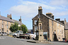
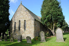
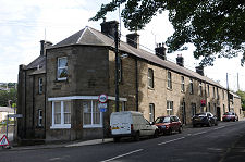
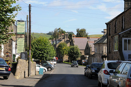
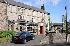
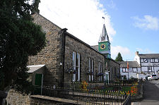
Bellingham itself is largely built of an attractive local stone and runs along either side of a very broad main street. If you are approaching by road from the south then, having crossed the bridge, and passed St Oswald's RC Church, you follows the road round some twists into the main street, passing the front the the imposing Black Bull Hotel as you do so. This has a slightly mock-Tudor feel, and is difficult to date. Many of the more substantial buildings in Bellingham were built in the 1800s, and it is tempting to suggest that the Black Bull may be among them. On the other hand, it stands immediately in front of (and largely hides) St Cuthbert's Church, parts of which date from 1180, and it is unlikely that the hotel would have been built on part of the churchyard. It therefore seems reasonable to suggest that there may have been buildings closing in this end of the main street from a very early date.
A little past the hotel is one of Bellingham's most striking buildings, the Town Hall, whose single storey frontage is given presence by a nice little clock tower. Because the ground drops away steeply, the rear of the Town Hall is much larger in scale, while nearby is the Boer War memorial. Close to this is the Rose and Crown, whose black and white mock-Tudor frontage looks like it might have been built by the same hands as the Black Bull.
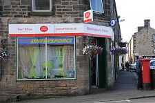
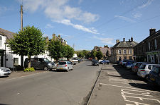
Further on the main street broadens out dramatically, but before it does so you pass the Cheviot Hotel on your left, a three storey stone building. In the modern era a broad main street is inevitably an invitation to park cars and provide bus stops, and Bellingham is no exception. The bustle of the town, the width of the street and the fairly informal approach taken to deciding what is, or is not, a parking place, can make crossing from one side to the other an interesting experience. A reasonable range of shops is on offer, including a post office, and there are a couple of banks housed in find stone buildings.
Towards the north-eastern end of the main street is the Methodist United Reformed Church, and on the opposite side of the road is an imposing white building. Today this is home to a cafe, but it was built in 1839 as the Bellingham Union Workhouse, modelled on the style of local farmhouses and large enough to house 53 inmates. To the rear is an infirmary building added in 1874, which is now used as housing.
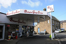
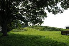
The road leading east from the main junction in the centre of Bellingham leads over a bridge over the Hareshaw Burn. Close by is Bellingham Garage and the Police Station. A little further on, a pasture on the right used as a camping ground is home to an irregular hill. This is all that remains of Bellingham Castle. Also in this direction, in the long disused railway station, is Bellingham's Heritage Centre, which doubles as the Tourist Information Centre.
The origins of Bellingham are closely connected with the castle, built in a location that commanded travel along North Tynedale and gained some protection from the Hareshaw Burn. It is thought that the first castle to appear was of a motte and bailey design and probably made of wood. This seems to have been constructed in the 1100s by the de Bellingham family. The original wooden castle was replaced in stone, presumably in the 1200s, and the castle and surrounding "manor" (estates) continued to be held by the de Bellingham family until at least the mid 1400s. A writer in 1825 talked of the castle being "in ruins", but it seems that all stone was recycled for building material in the growing settlement during the following century, for there was no trace of any buildings by the time of a report written in 1944.
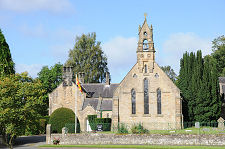
The next development in Bellingham was the building of St Cuthbert's Church in 1180. The distance this stood from the castle suggests that Bellingham had become a significant settlement by this time, effectively filling the gap between the castle and the church.
The industrial revolution arrived in Bellingham in 1838. A site on the east bank of the Hareshaw Burn, north of the old castle, was chosen for the site of Hareshaw Ironworks. Here locally quarried iron ore was converted into iron using locally mined coal. It is difficult to believe today, but a coking plant once stood here, alongside blast furnaces and an ore roasting plant. Though not for long, as the iron works had closed by 1848, presumably unable to compete with iron produced elsewhere in the north-east by iron works that had been connected to the rapidly expanding railway system.
Fourteen years later the railway arrived in Bellingham, which gained a station on the Border Counties Railway, a line running from near Hexham up past Kielder to Riccarton Junction in Scotland. The line closed to passengers in 1956, and was dismantled in 1963.
 Looking North-West Along Bellingham's High Street |

|
|
|
Visitor InformationView Location on MapWhat3Words Location: ///spends.warms.tripling |
 Cheviot Hotel |
 The Broad Part of High Street |
 A Rural Community |
 Front of the Town Hall and Clock |
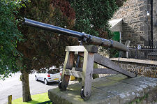 Decorative Cannon |
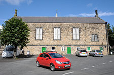 Rear of the Town Hall |
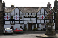 The Rose and Crown |
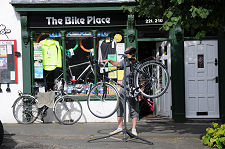 The Bike Place |
 Old Workhouse, Now a Cafe |