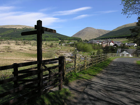
 Tyndrum |
Stirling is one of the 32 unitary council areas into which Scotland has been divided since 1996. It was also a district council area which existed from 1975 to 1996. It stretches from the area around Stirling itself west to the shores of Loch Lomond and north-west into the southern highlands. It is always a surprise to encounter a "Welcome to Stirling" sign beside the road when driving towards Tyndrum from the north or west: but this does show how far north-west the Stirling council area actually goes. For accommodation in Stirling and a full list of features, see our Stirling & Central Scotland area pages.
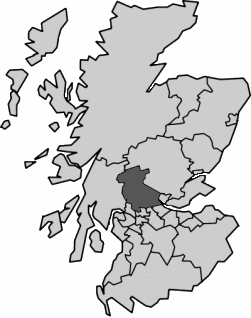 Stirling Since 1996 Note About Image Copyright |
Physically, Stirling is the 9th largest council area, but it is only the 25th largest in terms of population, which illustrates how remote much of the area is. Stirling is bordered on its west by Argyll & Bute; on its east by Perth & Kinross, Clackmannanshire and Falkirk; and on its south by North Lanarkshire, East Dunbartonshire and West Dunbartonshire.
Important settlements included Stirling, Bridge of Allan, Balmaha, Killin, Tyndrum, Crianlarich, Callander, Aberfoyle, Doune and Dunblane.
From the point of view of local authority coverage, the area now covered by Stirling formed most of the traditional county of Stirlingshire, plus a significant part of the county of Perthshire. A major reorganisation in 1975 saw Stirling District formed as one of three district council areas within Central Region, itself one of the 12 regions into which Scotland was divided. When regions disappeared from the scene in the 1996 reorganisation, Stirling became one of the 32 unitary council areas into which the country has since been divided.

|
|
|
InformationStirling Council:www.stirling.gov.uk |
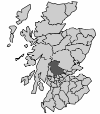 Stirling District, 1975-1990 Note About Image Copyright |
