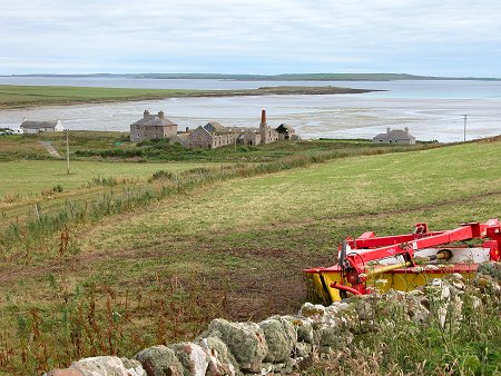
 South End of Sanday: Looking Over Stove, with Stronsay in the Distance |
Sanday is the largest of the north isles of Orkney and the most north-easterly of the larger islands: lying north of Stronsay and south of North Ronaldsay. The author Eric Linklater described its shape as like a fossilised, gigantic bat. Seeing this takes some imagination: you can also think of it as a fairly narrow and irregular island extending some 15 miles from south-west to north-east, with a peninsula stretching north from its centre.
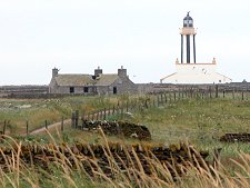
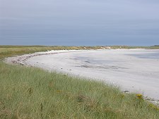
Sanday is very low lying, rising to a maximum height of 65m near its south-west end at The Wart, not far from Loth and its ferry terminal. The name of the island comes from the broad sandy beaches that fringe many of its long bays. The north and east of Sanday are especially low lying, making this the last resting place of many ships whose crews simply didn't see the island at night or in fog before running into it.
On an island without peat, the supply of wood that these wrecks provided kept generations of islanders warm: it has even been said that prayers were said in church to seek the Lord's assistance in ensuring that this supply of fuel didn't dry up. The construction of the Start Point lighthouse at the island's west end in 1806 helped mariners considerably, but it was only in the era of radar that Sanday became visible enough to be more consistently avoided.
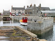
The main settlements on Sanday are at Lady Village, approximately in the centre of the island, and Kettletoft, on a small peninsula projecting south from the island. The island's population shrank from over 2000 in 1881 to 533 in 1991: and still further to 478 in 2001. More recently there has been a slight revival, with 494 residents being recorded in 2011. The signs of longer-term depopulation are visible throughout the island, and in some parts it seems that for every inhabited croft, cottage or farm there is at least one more abandoned and in ruins. There are also two ruined churches on the island: Cross Kirk, near Kettletoft, and Lady Kirk, near Lady. The latter comes complete with The Devil's Clawmarks, a rather spooky set of grooves in the balustrade at the top of a set of steps.
If the evidence of recent habitation is strong throughout Sanday, so is the evidence of its ancient residents, stretching back thousands of years. Sanday has been referred to as the connoisseur's island for archaeology, and wherever you look, there seem to be humps and bumps that date back beyond recorded history.
In part the preservation of the archaeology is down to the style of farming here over the centuries; and in part it is due to the fact that much of Sanday is physically growing rather than eroding. But it is also due to the respect of islanders for the hogboons. Islanders believed that each burial mound was home to a hogboon, an ill-willed and bad-tempered creature which went out of its way to cause trouble for any human who disturbed it.
Sanday's best known ancient monument is the Quoyness Cairn, on a promontory on the opposite side of Kettletoft Bay from Kettletoft. But it is indicative of the importance of the area that the promontory is also home to a further 27 cairns. In the far north-east of the island, excavations at Tofts Ness have revealed what is probably one of the richest archeological areas in Britain, with over 500 burial mounds plus settlement mounds and other features.
Meanwhile, near Scar, at the tip of the northern peninsula, a Viking boat burial was exposed during a storm in 1985. Subsequent work unearthed a beautiful whalebone plaque now on view at the Orkney Museum in Kirkwall: plus the skeletons of a man, woman and child; a sword; a quiver containing eight arrows; a comb; and 22 gaming pieces.
Sanday is also famed for its wildlife. Common and grey seals (or "selkies") are habitual residents and can often be seen in many places around the island. Otters are also resident, though much more elusive. Seabirds abound, and the beaches are famed not just for their sand, but also for their sea shells, many difficult to find elsewhere.
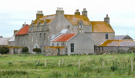 Scar House |

|
|
|
Visitor InformationView Location on Map |
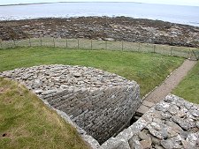 Quoyness Cairn |
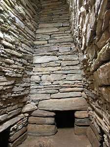 Quoyness Cairn Interior |
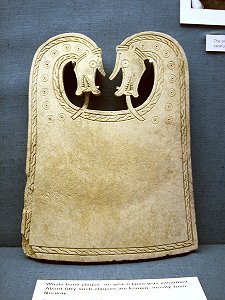 Viking Plaque found in Ship Burial at Scar |